WELCOME TO GREAT SEDONA HIKES!
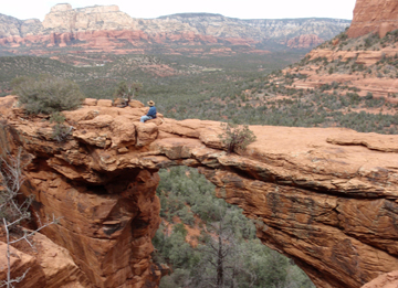
Hello hikers! Welcome to Great Sedona Hikes. Here you'll find free information on hiking in Sedona, Arizona. This website is also a way to post and share your photos of hikes around the Sedona area. Sedona is a very special place - the red rocks, the mountains and surrounding canyons are beautiful and we've tried to capture their beauty with these photos and descriptions. The photo above is me sitting on Devil's Bridge enjoying the great view.
I joined a small but active local hiking group and began hiking about 10 years ago. I've hiked most (but not all) of the Sedona hiking trails. The website was started in 2005 to share the hiking photos taken by members of our hiking group. Since then, the website has been expanded in scope so it now, in addition to the hike photos, provides Sedona visitors with broad information on the hikes and information on where to stay, shop and eat while in Sedona.
ITEMS TO ENHANCE YOUR SEDONA VISIT AND EXPERIENCE
You are going to have a wonderful time while visiting Sedona! And to make that experience even better, click here. You'll find information on our hiking books, our vortex books, GPS data files and something new - the Sedona Relocation Guide. Here's a brief summary:


We have now published two up-to-date hiking books. These books contain trail maps based on actual GPS "tracks" and specific directions to the trailheads. GPS points of interest and checkpoints are included for each hike. In addition to listing hikes by level of difficulty (easy, moderate, hard), how would you like to hike to an natural red rock arch? A vortex (see below as well)? To Indian ruins? How about a hike along water? And to help you decide on which trails to hike, we've included our top 12 hikes (we couldn't pick just 10!). The hiking books are organized so you can easily find the best and most beautiful hikes in Sedona. And these books are printed and bound in the USA.


If you are one of the many who have heard about Sedona's vortexes (and over one half of the visitors to Sedona have) and you are interested in finding and experiencing Sedona's vortexes, we have just published two practical, up-to-date books. Hiking the Vortexes will to help you find the four well known Sedona vortexes as well as 10 of Sedona's lesser known power spots. Hiking the Vortexes - Color Edition and the black and white version contain history and background on vortexes, how to prepare to feel the vortex energy, clear, easy-to-follow directions and detailed maps to the four main vortexes, plus directions to 10 other "power spots" where energy has been experienced. And these books also are printed and bound in the USA.
For those who are just interested in the four main vortexes, we have a Vortex Guide available. It includes detailed maps to the four main vortex sites so that you can enhance your vortex experience while in Sedona. The Guide is available for download by clicking here.
And finally, if you have a portable GPS, I have a GPS file containing over 90 Sedona hiking trails (including the vortex sites). Click here for more information.

Considering a Move to Sedona or an Investment in Sedona Real Estate?
The first time I came to Sedona I caught an intense case of "Red Rock Fever." If you catch it like I did, it is characterized as an overwhelming desire to be in Sedona or return again and again. If you want to know more about "Red Rock Fever," are considering a move to Sedona, or an investment in Sedona real estate, the Sedona Relocation Guide is the book for you. It contains tips on purchasing real estate, information on Sedona's history, weather, job opportunities, volunteer opportunities and more. Click here to see sample pages from this book. You can purchase the Sedona Relocation Guide by clicking here.
Click here for more information on all the items described above.
For a limited time, if you book your stay at the Baby Quail Inn for a minimum of 2 consecutive nights from now until January 31, 2013, receive a copy of Great Sedona Hikes hiking book (a $16.95 value) at no charge (sorry, new reservations only). Click here for more details.
GETTING READY TO HIKE
OK, enough of the sales pitch. Let's go for a hike! But before you go hiking, you should stop in to the Sedona-Oak Creek Canyon Chamber of Commerce Visitor Center or the Red Rock Ranger Station Visitor Center for more information on a particular hike and to obtain the latest information on road and trail conditions. The Sedona Chamber of Commerce Visitor Center is located in Uptown Sedona at the corner of Forest Road and State Route 89A (at GPS coordinates: 34° 52.119' N; 111° 45.702' W). The Forest Service Visitor Center is located on State Route 179, 6 miles north of I-17 or about 2 miles south of the Village of Oak Creek (at GPS coordinates 34° 45.452' N; 111° 45.855' W).
You'll need a Red Rock Pass or equivalent to park at many trailheads on the National Forest for your hike. Click here if you'd like to see where Recreation Passes (i.e. Red Rock Passes) are now required and where there are some special fee areas (note: this is an 8.5 MB file so it may take a few moments to download). And effective in November 2012, if you have a Senior Pass, show it at the three special fee areas and you'll receive a 50% discount on the parking fee.
The Forest Service and our hiking group cannot stress enough that you be prepared before you begin hiking, even for a short day hike. The humidity is very low here and you need to take plenty of water to avoid dehydration, particularly in the summer. Sunscreen, a hat, compass, maps or a portable GPS, a charged cell phone (although many trails do not have cell phone coverage) and good hiking boots are among the recommended items you should have with you. And you need to let someone know where you are hiking and when they should expect you back. Finally, be sure you are off the trail by sunset because hiking back in the darkness will likely get you lost, perhaps injured and in need of rescue. Here's a page with the equipment you'll need for a successful hike.
ORGANIZATION OF THE WEBSITE
I've tried to keep the website simple - to focus on the hiking information rather than have a lot of fancy graphics. The hikes are organized by level of difficulty (EASY, MODERATE, and HARD HIKES ), based on ratings determined by David Butler and myself in our hiking guide, "Great Sedona Hikes Revised Second Edition" and assessment by our hiking group. If you are unsure what level of hike you are capable of, start out with the EASY hikes until you are sure you are up for something more demanding.
An ALPHABETICAL LIST of all the hikes on the website is here.
EASY HIKES are here.
MODERATE HIKES are here.
HARD HIKES are here.
The most recent revisions/additions to the hike descriptions are: Fay Canyon Trail, Devil's Bridge, Cibola, West Fork, Broken Arrow, Llama Trail, Wilson Mountain North, Huckaby, Airport Loop, Submarine Rock
A list of our favorite hikes is here. (I show 10 hikes on the website, but have expanded the list to 12 in the hiking guides)
A list of hikes by distance/level of difficulty is here.
Vortex hikes are listed here (as well as a brief history and explanation of vortexes).
Hikes near/along water are listed here.
Hikes to/near Indian Ruins are listed here.
GPS data files for the hikes are found here.
In addition to the photos from the hikes, we have some exceptional photos taken by our hikers. They are here.
Information on mountain biking is included here. More information on biking and camping is included here.
SEND IN YOUR HIKE PHOTOS
Your photographic contributions to the site are always welcome (see the email address near the bottom of the page). Contributing photographers include: Helen Mueller, Darryl Thompson, David Butler, Lou Camp, Rich Jones , Jon Dorsey, Stephanie Vaughn, Eric Murphy, Sree Remella, Tom Solon, Tammy Tyndall, and Jessica Bohan.
The site also includes interesting and informative pictures of the Sedona area and beyond, courtesy of members of the hiking groups.
OUR RECOMMENDATIONS FOR EATING, LODGING, ETC.
I receive many requests for information on where to eat, where to stay, what
to do, etc. while in Sedona. As a result, I
have added a page of links for information on the Sedona area; places to enjoy a bite to eat or some liquid refreshments,
and some very nice and affordable places to stay. We've tried these places
ourselves and we don't receive any compensation from them, FYI. So if you are
interested on where we refer our friends, be sure to check out
the
links
If you have questions about Sedona go to
Sedona FAQs for more detailed
information on the weather, location, what to do (besides hiking), etc. in
Sedona. And if you like what you
find on the website and would like to make
a donation to help maintain the website please click the "Donate" button below.
Any amount is greatly appreciated.
New
information is constantly being added and updated. So check back often. If
you have comments, suggestions or photos you think might be candidates for
the website, or you are in Sedona and would like to join us for a hike, please email me. So enjoy your visit to the website and
welcome to Sedona!
William
Great Sedona Hikes:
Revised
December 23, 2012
Web Page by William Bohan (billbo@greatsedonahikes.com)
send an email
with your comments/suggestions/photos to Bill
Entire website ©
copyright 2009, 2010, 2011, 2012 by Bill Bohan
Disclaimer: This web site is intended to
show some of the beauty of the hiking trails around Sedona, and is not intended
to be used as an authoritative hiking guide. Road and trail conditions can and
do change, and you are strongly encouraged to get up-to-date hiking information
before you set out; the Sedona Chamber of Commerce Visitor's Center in uptown
Sedona and the Forest Service Ranger Station located on State Route 179 are
excellent sources of information. Hikers are responsible
for their own safety (see before you go). The contributors to "Great Sedona Hikes," and everyone
associated with it directly or indirectly, disclaim any liability for damages,
losses, or injuries that might occur to those using this website.